Showing posts with label Trail Photos. Show all posts

Sunday, March 10, 2013

Mount Finlayson Victoria, BC Double Summit Trail Run (video and trail photos)


Mt. Finlayson from the Little Niagara Train Trestle!
Mt. Finlayson is a seemingly small hill in the Goldstream Park about 15 kilometers north of downtown Victoria. At 410 meters (1374 for my imperial friends) it doesn't seem to encapsulate the grandeur of runs in the Coast Range of Northern Vancouver, or even large mountains on Vancouver Island, but what it lacks in size it makes up for in personality. The short trail to the summit runs an average grade of 20% and often requires class 3 scrambling.

There is a more mellow, but still relentless approach on the north slope, that doesn't require scrambling and isn't as exposed but still requires a fair chunk of work to make the summit quickly. This was my first plan of attack. Being one of the first warm Saturdays of the year I knew that Victoria's most popular mountain would be a zoo. By parking off the lesser known trail head, and climbing Finlayson via the backdoor first, I knew I would be able to focus on my first solid summit without navigating around a bunch of people.

My plan worked perfectly and I only passed one or two lonely souls on the back side.

My legs felt fairly strong as I began to coax them into a solid pace for the first flattish kilometer. I knew that there was nearly 400 meters (1000 feet) of non-stop 20% grade ahead of me so I held back and just tried to  conserve energy. Before I knew it I was ascending the mountain, climbing steps, and dancing between rocks. I applied constant pressure to my legs. Not so much that they blew up, but when they began to complain under the constant accumulation of lactic acid, I didn't give in. I kept pushing them up the trail as it wound it's way up the mountain side.

About half way up I took my first walking break (other than a few short rests to set up my camera). The walk was great and gave the lactic acid a chance to be whisked away by my blood. No sooner did my muscles begin to recover then I would start right up into a trot again only to find the acid come swelling back into my muscles quicker than ever. This is what hill running is all about. How well can you ignore the screaming voice of your muscles? Your muscles are doing everything in their power to get you to give in and to stop. It is these steep brutal hill runs that allow your mental toughness an opportunity to be developed and pushed. Without hills I wouldn't be half the runner I am on the trails or the road.

The summit was quickly won in about 24 minutes and I felt great. I knew that I possibly could have shaved another couple of minutes off but I still had an extremely technical descent and ascent via the ledge-choked south slope.

Mount Finlayson out and back route plus mile markers.
I started down the steep technical face and sat back in the saddle and let my quads begin the main task to absorb my forward and downward momentum. I was glad I had been running downhill hard for several months now and I could count on my quads to take the brunt of the force as I clomped down the face. I would crab crawl, slide, and leap down a large ledge and then I could run a short distance of smooth sloping rock before finding the next ledge waiting to throw me off the mountain. I began to pass group after group of hikers; mainly young university students in their Nike Free Run's. In fact I saw more Nike Free Runs on that mountain than I have in all the running stores I have ever frequented combined. I don't know how Nike does it but they somehow find a way to convince the majority of young active people to purchase their shoes.

I really wanted to set up some great shots of the many challenging ledges and rocks that must be carefully dealt with to prevent injury, but the crowds were everywhere so I only captured a few shots of the ledges so my video looks quite a bit tamer than it is in reality. I worked at keeping as much of my feet in contact with the rocks as possible to maximize my coefficient of friction and keep me securely glued to the hill. Halfway down my pace began to slow as my quads became fatigued. I just relaxed and eased back to let my legs have a chance to recover. Before I knew it the technical portion was finished and I was sailing to the main parking lot.

I quickly turned on my heels and retraced my steps up the trail. The ascent was much safer as far as the risk of falling but at that point in the run my legs weren't really excited about running 20% grades again. My muscles' voice was loud enough to drown out my will power so I began to power hike instead of run. Even power hiking I could tell I was maxed out. My heart rate was through the roof and I could occasionally see swirls come and go as anyone with low blood pressure can relate to. I made a game to see how many hikers I could overtake (about 30). This kept me red lined at my max and ensured that I didn't settle for anything less than 100%. I scrambled my way up the ledges as the warm March sun beat down on me, and reflected off the worn rocks, giving me a second dose of radiation. I wasn't complaining though. The sun recharged batteries that had worn down to dangerously low levels after the long sunless winter!

I summited again taking some footage of a quick victory pose and then I bailed back down the north and somewhat abandoned trail I had first climbed. The descent was slow because my quads were knackered. They felt like they had just gone through a meat grinder. How I love the feeling of thoroughly thrashed quads! I took it easy and soaked up a bit more afternoon sun as it penetrated through the firs and drenched me under large patches of gold between fields of cool blues and green.

What a great run! I went home feeling fatigued muscles and the warm glow that follows a difficult workout in a beautiful location!


Gold Stream Park trail maps


Mount Finlayson drenched in afternoon sunlight!
Here is the video from the run! I hope it illustrates even a little bit of what it is like to run on this awesome mountain!

Monday, March 4, 2013

Mount Work Victoria, BC Trail Run (Video and Trail Photo)

Mount Work is a rounded and wooded hill in the Gowlland Tod Park with miles of trails that overlook the Saanich Inlet and Finlayson Arm. It is a steep and short little trail but extremely fun to run.

I started at a steady pace and quickly found myself running up a trail with a trickle of water flowing down it. I was concerned that I would get rained on but upon parking the clouds broke and I was met by rays of warm March sun penetrating the undergrowth. The hill quickly steepened and I had to adjust my stride to short and quick little steps. There were large portions of trail that had accrued puddles from previous rain storms. The rocks were particularly perilous as they were wet, mossy, and extremely slick. I quickly powered my way to the summit taking advantage of any flatter portion of trail to run, and power hiking the steeper portions of rocky trail. The summit was beautiful and the weather perfect for a Saturday run. The return trip was punctuated by tromping through deep puddles and bombing down steep stretches of single track. It was a great little run and I was extremely happy with it, and was reminded once again why I love running so much!

Finlayson Arm and Saanich Inlet from an overlook near the summit of Mount Work in the Gowlland Tod Park!
Below is a nice video of the run with a great little running song!

Wednesday, February 27, 2013

Spring-like Trail Run on Vancouver Island (trail photos) - Late February

My good friend Tim and I finished up our seventh week of our 2013 training block. While Tim was dealing with one of Utah's colder snowier winters, Vancouver Island has experienced quite a mild winter, which means spring-like conditions are here a little early. 

I must admit I feel bad as Tim posts about his training runs in sub-zero weather and blustery whiteout conditions. Meanwhile I am in short sleeves and shorts gliding around a mountain, surrounded by succulent chartreuse leaves, and single track bordered by emerald carpet. Tim is definitely building up a nice resistance to the many trials facing us this year by running in the challenging conditions, meanwhile I am getting spoiled and I will not be quite as accustomed to the difficulties that lie ahead! 

I am not complaining though. I openly admit that it is fantastic to run through the budding new life of Mount Doug in February. I still remember when I was training in Utah, and I would stand on the driveway in the dark early morning waiting for a snowplow to clear the road so I could run in its wake, as new snowflakes quickly accumulated on the freshly plowed road. Those seem like great times in retrospect but at the time I wasn't always so thrilled. 

Week seven was a great week for me and the outlined schedule pushed me to run hard and pick up the pace. 

As my degree comes to a close and I likely head out for an unknown future in academia and a new home I find myself already missing Victoria and the Island. It was here where I feel I have grown the most as a geologist, a student, and in life in general. I will always have fond memories of my late winter sojourns on the green sun-drenched slopes of Mount Doug. I guess I better really enjoy this spring as it is likely my last one here anyways!


 Succulent new growth on Mount Doug in mid February!

 The green north slopes of Doug in late winter.

 Late winter trail running on Doug.

A lone arbutus on Little Doug with rural Victoria behind it.

Tuesday, February 19, 2013

Winter Trail Run at Night Victoria, BC (photos)

It was already 9:00 pm and we had just finished celebrating a new BC holiday called family day. We went to a friends house and had a wonderful time around their fire pit roasting weenies and making smores. I hadn't planned on the fire pit outing and so it displaced the time I had set a side to run. On the drive home I debated whether to run or not. Once I arrived at the house I knew I would regret if I didn't get my run in so I put on my gear, grabbed my headlamp, and headed out the door. 

It had rained earlier in the day almost spoiling our campfire but the rain had abated and the clouds dispersed. I chose to run part of the chip trail that circumnavigates the UVic campus but then to summit a small hill nearby called Mount Tolmie. Somewhere in the woods an owl hooted in that deep penetrating hoot that fills the forest, making an eerie seen as I ran through the darkness. Any time I run in Victoria at night my mind always wanders to the many cougar sightings that crop up every year. This night was no different but it didn't really frighten me, more of a heightening of my senses. I exited the forest and ran toward Mount Tolmie. 

The little hill is by no means impressive or challenging in the way that the Rockies or many western mountain ranges are but it does get your blood pumping and it is easy to make many repeats to gain some hill training fitness as well. This night was just going to be one single summit and a return home. The stars began to blaze through the lifting clouds on my final approach to the summit and after coming up over the crest of the final hill I was completely surrounded by the warm glow of street lamps and houses and the scintillant haze of downtown on the horizon. Mount Doug was back lit showing it's distinctive silhouette against the partly cloudy sky. I was extremely pleased I gutted it out and got my run in. Many times it is when I am the most conflicted whether to run or not that I am usually rewarded the most for not giving into that voice in the back of my mind. This run was truly a jewel in my early training year and I was rewarded with an inspiring view few people are able to see because they are busy living their lives and can't motivate themselves to explore and enjoy the world around them.

The return trip went as smoothly as I could have hoped for and I made it to my house where I cleaned up and slept the sleep of the training runner.


My headlamp can be seen bouncing down the chip trail on this long exposure shot (top). On the summit of Mount Tolmie with part of the city lit up behind me (middle). Mount Doug back lit showing its silhouette (bottom).


Downtown Victoria from the summit of Mount Tolmie (top and middle). A grainy shot of the stars peeking from behind clouds taken on my approach to the summit (bottom).

Monday, February 18, 2013

Sunny Winter Trail Run on Mount Doug Victoria, BC

With anticipation I awoke to a bright sunny February morning on Vancouver Island, ready for my Saturday long run. The warm sun and mild temps suggested that it was time to switch out the tights and toque for shorts and a running hat (at least for the day). I coaxed my body into a light jog at my usual training grounds on Mount Douglas in Victoria, BC. Having trained for about 4 weeks I was starting to get into a groove and quickly found a pace that felt great. Wisps of cool morning air brushed across my bare legs as I navigated the damp trails that wrap around the base of Mount Doug. It was one of those mornings where everything was clicking between my training, diet, and sleep - and they were all in sync. I was motoring through the miles effortlessly. The climbs were still more than I could manage without a walking break or two but my lactic threshold was definitely heading south. The downhills felt fluid and easy as my quads extended and contracted to slow my descent. I urged my legs into a fast clip as I cleared the wooded slopes and entered the sun-soaked exposed south slopes. It was amazing to be cruising over the trails in the sun. Overall the run was relaxed, playful, and rejuvenating. By the end I was thoroughly exhausted as a result of my eagerness to run quickly in the beautiful crisp morning air.


Sun-drenched trail on the southeast apron of Mount Doug (top). Climbing one of three major ascents out of the southern wooded approach (middle). The view west from the summit of Mount Doug showing the beautiful greens that are so prevalent this time of year (bottom).


Looking east out towards the Gulf islands of the Georgia Strait, halfway up my first major climb (top). Sun peaking through the undergrowth on Doug's south slope (middle). Circuitous trail through moss and ferns (bottom).


Below is a video capturing the run and was featured on the local newspapers (Times Colonist) entertainment page here.

Sunday, January 13, 2013

2013 - Week One Long Distance Training Complete

Week one of training with my friend Tim for long distance has come and gone in a flash! We ran fairly low distances with rest days in between because we are just beginning to ramp up to further and further distances. The photos below show some shots taken on Saturday's run (and show up again in the video, sorry for the redundancy). I only took photos on Saturday because of low light and poor weather for the other runs earlier in the week.


On Monday I awoke to the sound of rain pounding the window and I knew it would be a wet run. I left my house in the dark at 6:00 AM. I ran the chip trail which wraps around campus and I wasn't surprised to be the only one on the trail. It had been raining all night and the rain quickly collected in puddles in all depressions along the trail because the pore space in the soil couldn't soak up any more water. The trail is a loop, therefore I found myself for about a quarter of the run, running face first into great big drops of rain as the wind drove it almost parallel with the ground. I quickly ran the loop and crossed bridges which spanned swollen creeks dotted with the large stalks of skunk cabbage. My shoes slopped through the puddles; soaked through. One nice thing about getting your feet wet immediately is that you no longer need to worry about keeping your feet dry so from then on you can just focus on running because your shoes aren't going to get any wetter.

Wednesday had much better weather conditions and was almost too warm for tights and I really worked up a sweat quickly. I really pushed on day two for some reason, my body just felt like pushing it. I really hammered the Chip trail running it clockwise, opposite from Monday's run. I find when I run the same loop route multiple times in a week it is very nice mentally and physically to switch the direction of the route. It keeps it fresh, and helps keep you running evenly, and wards off ennui which can accompany any runner who runs the same course often. I finished feeling well tired, and a bit sore from my pace, but I felt I put in a great workout.

Saturday was very cold for Victoria and saw temps below freezing. It was odd seeing frost and snow on the ground. Even the puddles had a thin film of ice. I chose Mt. Tolmie as my destination. This allowed me to run some flats but also work on my up and down hill running. The sky was bright and the colors vibrant. I spent a considerable amount of time filming the colors and setting up shots for my short video. As I was returning from the summit I saw that my SD card was full and that I had not recorded much at all. The many minutes of video I so painstakingly tried to capture was lost. So the video below only shows a minute or two of footage of 15 or so that I captured. Oh well; it also cuts off abruptly, but I couldn't be bothered with fixing it. I will just chalk that up to experience and remember to check my SD card before running in the future. The run was great and I enjoyed the run immensely.

Tim and I are also swapping music for each run. We each suggest a song from our own repertoire to the other and then run with it as our first song of each run. It has been a lot of fun and has made each run exciting as we each get to look forward not only to running the same distance together, at roughly the same time, but also to the same songs! It also allows us to discover new music. I highly recommend it to any runners who like to run with music and want to spice up their training playlist. It is nice to be able to share the fairly solitary pursuit of long distance running with someone else and connect on another level. I think we will keep this up as long as we can!

My video is the first one with Tim's video for the week shown last!


And here is Tim's video for week one. Same training routine just 1000 miles to the southeast!


Saturday, January 5, 2013

Mount Douglas Victoria BC Trail Run with photos Jan. 5th

My best friend Tim and I will start to officially train for the 2013 season beginning on Monday. He lives in Utah about 900 miles to the southeast of my current home of Victoria, BC. So to train together we have to rely heavily on the miracle of technology i.e. social networking, YouTube (highdef video conversations), and e-mail. These modern conveniences let us stay connected as we train together and follow each other's progress while also carrying on long distance conversations about this beautiful art we call running. We will also be doing the same training program; one Tim has designed. This program is tailored to help us get back into the groove of running consistently between now and April (get the cobwebs out after the holidays) and then really hone our speed and endurance come the summer so that we will be able to handle whatever running adventure we can get ourselves into. Besides Tim's marathons and RAGNAR races he has planned, we are also looking at our yearly epic trail run to be a beast and I will blog about that in the future!

This past week I have tried to run some slow distance just to wake up my circulatory and respiratory systems while also conjuring up some muscle memory in my legs. I dropped off my Christmas tree at the University Track and donated to the track team to help support track and field athletics (the track team recycles trees to raise money). I then started my run at Mt. Douglas my usual training ground. The weather was perfect 9 degrees Celsius or 48 Fahrenheit; overcast with a bit of sun peaking through now and again. It felt like running in April in Utah but these conditions are quite common this time of year here on the island. I took my time and worked my way up the side of the mountain focusing on taking small steps at a faster cadence and also staying relaxed. The majority of the trails I run on are devoid of my fellow bipedal com padres since the trails I run require you to get muddy and are somewhat technical. I summited the big mountain and snapped a few shots but it was so crowded with others in the observation nest that I quickly dove off the gnarly steep side of Doug in full retreat. after picking my way down the exposed slippery rocks I ran the Km of slight uphill trail towards Little Mt. Doug; stepping in small spaces between roots and rocks. Little Doug is a small blister on the west apron of it's bigger brother. I really like Lil Doug, though much smaller, it also has a lot of personality (the trails do anyways). I chilled on the summit for a few minutes and reveled in the feeling of running free and the nice relatively warm weather. I bounced down the steep rocky face and finished my run on a trail that hugs the base of Big Doug and takes me back to the trail head. I saw that some of the underbrush was starting to already bud. How I love spring on the island! In Utah winter often gives way to summer with an extremely abbreviated spring (often only a week or so) but on the island spring dominates both winter and summer and often seems to make up half the year. I took little easy strides and focused on my form and got excited for this years training with Tim, and I tried to let that small burst of adrenaline at the thought of training with him carry me all the way to the finish extremely quickly. It was another great run and 2013 is turning out to be a great one. I gave this run 7 out of 10 bean burritos (with Serrano peppers, my after run snack).


A Mt. Doug trail running video.

Friday, January 4, 2013

New Years Day run through Thetis Lake Regional Park

For two years in a row I have ran in Thetis Lake Provincial park on New Years. It is a little gem of a park only about 10 minutes from downtown Victoria. This park can be crowded and is a favorite of dog walkers. The secret to avoiding the masses is to run the narrow and muddy trails on the perimeter of the park rather than sticking to the main crushed gravel trail that circumnavigates the lake shore. This is a great solution if you don't mind getting some swamp feet now and then. The weather was chilly 5 Celsius or high 30's Fahrenheit with a hazy sky but also some sun.

I first summited a small hill (Seymour) just to get the blood pumping and get my core temp up. The hill sits on the southeast side of the lake and gives impressive glimpses of Thetis to the west. Running up the south slope of Seymour is one of my favorite trails in the park because it is a vastly different ecosystem with more grass and spaced out garry oaks and fir trees; it reminds me of running in Utah's Uinta mountains or other alpine forests in the Rockies. The summit consists of a faint trail which rolls over the mossy rocks and is dotted by arbutus and douglas fir.

The descent from Seymour is just as spectacular and takes you right down to the lake shore via a swerving length of single-track that cuts through broad-leaved shrubs and Oregon grape. I ran the main trail for a short distance just to get me to the Seaborn trail turnoff which connects to the McKenzie creek trail. Once you veer off the main trail you are back to solitude and complete isolation. Only a few of the hardiest hikers or trail runners venture down these trails because they meander along side the creek in a fairly boggy area. Many portions of the trail consist of roots, mud, and standing water. The ecosystem is one of moss-covered western red cedars, rocks caked with succulent ferns, mossy logs and an overall swampy biota. A little slice of pacific northwest trailrunners paradise.

With limited fitness at the moment I was forced to take things fairly easy so I didn't run to the summit of Stewart mountain but turned back after a few miles on the McKenzie creek trail. I retraced my steps and did the run in reverse and had a thrilling return trip filled with lots of playful running along the creeks and rolling hills in an exhilarating workout. Overall I give this run 3.5 out of 5 wet Brooks Cascadias; high marks indeed for the first run of 2013!


Tuesday, October 23, 2012

Arbutus Cove Run October 22, 2012


I really enjoy running in the rain. I should rephrase that, I really enjoy running in a light drizzle. The rain keeps you cool and is also a bit invigorating so that you seem to find a little extra energy to draw from. I also love running in the Autumn not only because of the obvious reasons of vibrant fall colors and cooler temperatures but also knowing that the racing season is over takes some of the pressure off to perform and train at such a high level. You are able to relax some and enjoy running for the simple act of covering distance efficiently. Today's run checked both these boxes. I stepped out my door and was first greeted by a brisk drizzle, during the Island's first true cold spell the year; it was a little like jumping into a cold pool, but like swimming in a cold pool, it is only a matter of time before the body adjusts and the exertion makes you quite comfortable. The smell of earth and leaves in various stages of decay accompanied me as I started down the trail. I decided to run Arubutus Cove a small sandy bay near my home. As I ran down the stairs to the beach, I could hear the surf which meant high tide. The waves were crashing right up against the high water mark which only left a small strip of runnable sand. It would be possible to run this strip, which would include some scrambling on slimy rocks, but tonight I opted to head back to the road and circumnavigate the beach and run to the other end. The other end of the cove has larger grassy areas along the headlands strewn with large arbutus trees, both lush and green, and dead and scraggly. I enjoyed the view and ran down the 40 or so steps to the beach. It was a superb run at the height of fall. I retraced my steps and did the route in reverse for a simple 35 minute run. Nothing too serious just enough.


Tuesday, January 3, 2012

New Years Eve Long Run: Getting Lost on Vancouver Island

On top of Seymour Hill

Going for a run in a new location is always exciting and really increases your love of trail running, and this New Years Eve run was no different. Although I have been living on the Island for over three years now I still haven't even began to explore all the trail systems and parks even a few miles from my house. One area I haven't spent much time is Thetis Lake Regional Park. The park is wildly popular among residents because of its beautiful trail system, scenery, and more likely its appeal to dog walkers. It also hosts trail races like the extremely popular Gunner Shaw 10K and the Stewart Mountain 10 miler. It is amazing that I haven't run this park but one other time, with its amazing trails and rich cross-country race history. In the end, the main reason I haven't spent much time there is I don't like driving to a run if I can reach a similar type of run easily from my doorstep, I don't like paying for parking (May-September), and lastly I am not a huge fan of trails populated with dog walkers. I don't mind running around dogs on most trails but sometimes really popular trails get so choked with our canine friends it can really slow you down or prevent you from ever really reaching that flow state that can be so fickle to achieve.

That being said I decided it was time to give the park a try as my last run of the year. I went early enough in the morning that I figured the majority of dog walkers would still be avoiding the morning chill. I chose a course to run that followed closely to the Stewart Mountain Course with the exception of me running a smaller knoll called Seymour Hill first, and then also running to the summit of Scafe Hill as well as Stewart Mountain. The trail system is honestly straight forward and well marked so as to why I had such a hard time navigating this run is beyond me. Granted I haven't spent much time there before, and the main route has no fewer than 15 forks in the trail, but in the end I think I was just so busy enjoying the run that I wasn't paying much attention to what I was doing, but I am getting ahead of myself.

I started the run at a nice slow chug up the south side of Seymour. My blood began pumping and I quickly warmed up in the rays of the winter sun. I was in awe at how many cars were in the parking lot but the majority of people walk the main trail around the lake, so I had Seymour all to myself. The views of Thetis were absolutely beautiful and I was able to do one of my favorite things on the island which is glide along the tops of the hills over the moss covered rocks with amazing vistas all around me. After taking a photo or two at the top I began my descent and after a mile of beautiful twisting, turning, descending, single track I met up with the main trail that ribbons around the shore of Thetis Lake.

I knew that I needed to stay left near the shore a certain distance and avoid several right hand turns until I reached the correct right that led me north towards Stewart Mountain. The problem was in my attempt to hug the lake I took the trail that heads due south along a peninsula between the upper and lower Thetis Lakes and after a mile on that found myself literally back to where I parked. No Problem I thought I will just head north along the west shore of the lake and eventually meet back up with my main route to the north. In all, this wrong turn cost me several miles, but the trails were so amazing and the weather so perfect I just considered it a privilege to explore a few extra miles of trails.

I then began to probe my way toward the northwest end of the lake to find my main route to Stewart Mountain. I was unsure which trail I needed to take because I strayed from my original route that I had planned on running. So I found myself literally running every off-shoot trail I could find. I would run it until it dead-ended into a road, parking lot, race car track, or gravel pit. I was a bit frustrated to be honest but the trails were amazing and I had them to myself because I was away from the main lake. Eventually I found the correct trail after literally running every wrong trail in it's entirety. I thought it is a good thing I like to run long distances because otherwise I would be spent before I ever made it to the north bound trail that takes me to Stewart Mountain (which should have only taken about 25-30 minutes to reach).

I ran over streams, and puddles, and through trails with water pouring down them. I ran past old rusty cars and by old water tanks. It was a ton of fun to explore and every corner was new which is why I love running new areas so much. I finally reached Stewart Mountain an hour later than I had originally planned. At that point I realized I packed zero fuel and only had water and I could use a calorie or two going into the climb but pushed myself and thought it was good fat burning training. At one point I saw an overgrown trail that appeared to be a shortcut and would shorten my climb by quite a bit and so I took it. Within a minute I found myself chin deep in ferns and soggy grass. I stepped in a puddle that went up to my knee and finally broke through to the main trail after quite a battle with the brush, and while I was in the bush I donated my maps to the undergrowth. Finally I made the summit. It wasn't by any means a spectacular summit but it felt nice to lay down and I enjoyed the solitude and peace that comes from going further than anyone else is willing to go. I snapped a few photos, and took some footage, got a large swig out of the water bladder and headed back.

The way down was uneventful and now that I had a feel for the area I ran straight back to my car even without my maps that apparently didn't help anyways. What a great run and way to end 2011. I finished up the week with about 40 miles and felt really happy with each of my runs.

At the bottom of this post is the video I made of the run with another great song by Seven Mary Three. Feel free to laugh as I get lost, take shortcuts that don't pan out, and end up losing my maps (I know my wife sure had a good laugh at my expense). The video is in high definition so toggle to 1080 P before viewing to get a better picture!


Seymour Hill Ascent


Seymour hill


Thetis Lake


Running the Mossy Rocks


On the Summit of Stewart Mountain


Tuesday, December 27, 2011

Boxing Day 2 hour run.

This semester was definitely an endurance event. Everyday felt like I was just trying to run to the next tree, or next stone, just like the late miles of a gnarly distance run. Instead of running to objects along the trail I was trying to just finish the next paper, the next assignment, or make it to the next meeting with my adviser. I was extremely relieved when it was all said and done and I could enjoy some down time with my family. I was also stoked to hit the trails again. So on Boxing Day I went out for a slow two hour run. I ran beach, I ran roads, I ran creeks, and I ran forest. It felt amazing! It was nice to actually be working towards my fitness and running goals again instead of buried in the books. The run was slow and painful but the light drizzle and beautiful Vancouver Island winter day recharged the batteries and I felt whole again.

Below are three shots from the run that represent the amazing variability and beauty I get to emerge myself in every time I run out the door.

Douglas Creek

Mt. Doug single track!


Arbutus Cove Beach


I haven't included much music in my posts of late so I am going to include a song that helped me through another brutal semester. This is a great song by Seven Mary Three an amazing and underrated band. They formed in 1993 in Virginia as teenagers but really broke out in 1995 with a hugely popular debut album "American Standard" and are a quintessential American band; two guitars, bass, and drums.

This song "Over Your Shoulder" comes from their 3rd and likely least popular album "Orange Ave." released in 1998. The band was having issues during it's recording, which affected its final sound, but it did have a nice song or two and this is one of them. The reason this song helped me this semester is that as I was pulling my first or even second all-nighter in a row, and I felt like just laying in bed and not ever moving again, I would throw on this song and soon I would rally as I realized that I just needed to hunker down and before I knew it the assignment or deadline would be "over my shoulder", and ultimately the semester was quickly behind me. It goes without saying that this song also applies to long distance running, we all come to those low spots in each run, each season, each year where the run or running isn't going exactly how you planned and everything seems to be going pear-shaped, but sooner or later it is over your shoulder. A nice song to pick you up when feeling overwhelmed. Enjoy!

Monday, November 28, 2011

Winter running (photo from this evenings run)


Winter has now settled over the Island and the days are getting very short which means running in the dark. I thought I would take my camera with me and snap a shot or two. This is my favorite photo from tonight's run.

This semester has been really tough, but running has helped me keep my sanity. I can't wait to have this semester behind me. Grad school is an endurance sport and I feel like I am using similar tactics to long distance running to keep going. Very similar to picking a tree or rock to run to, and repeating the process when you are really knackered; I am having to pick many small goals to work towards during my studies each day. If I look at the big picture it is a bit overwhelming, so by just focusing on finishing this paper or writing a paragraph is what is allowing me to keep on plowing through. Running is definitely applicable in many areas of my life!

Saturday, April 23, 2011

Gowland Tod Park 4 hour run through the emerald hills

I awoke this morning and loaded my running pack with 2.5 liters of water, my camera, and a peanut butter and honey (PB&H) sandwich. It was going to be my first 4 hour run I have done for many months. Since I am running strong and consistent, I felt I was ready to start doing what I love most- long runs with loads of relief.

I picked the Gowland Tod Range to run for several reasons. First it starts at about sea level and climbs as high as about 1350 feet at Jocelyn Hill and then dives down again and back up to 1000 feet at Holmes Peak after which you turn around and climb them both again in reverse. In total it has some good elevation and relief. The second reason I love this route is the views are breath taking. The entire trail parallels the Finlayson Arm of the Saanich Inlet and you can see the ocean, surrounding mountains, and forest. I believe every trail runner should have an opportunity to run this course at least once in there lives.

The weather was superb without a cloud in the sky and temps were hovering around 60. After arriving at the trail head I started my run and within about 10 minutes found myself cranking up the first hill, which climbs unrelentingly for several miles. The trail is rocky and winds it's way from near the ocean south towards Squally Reach. My legs were a bit tired from this week's runs but once I started motoring up the trail I began to relax and find my pace. Though not the fastest pace, it was maintainable and comfortable, and I knew it would last for 4 hours so I stuck with it.


Squally Reach in the Gowland Tod Range. Floating over the grassy hummocks!


I arrived at the squally reach lookout and drank in the most amazing view. I could see the ocean and Salt Spring Island, even Mt. Baker was dimly visible looming over the eastern skyline. I ran across the grassy hummocks and could swear I was floating.

After playful running on the reach I began to turn my attention to summiting Jocelyn. Jocelyn is a large grass covered blister rising nearly 1400 feet above the ocean. The trail from Squally Reach to Jocelyn undulates and ascends and descends over uneven terrain. Though most of it hovers around the same elevation there is plenty of ups and downs to keep you earning your forward progress. You feel you are nearly to the summit but then the trail turns north and you almost back track a Km before curving around to the south again. After turning to the south you begin to overlook the ocean once again and the views are breathtaking.


Approaching Jocelyn Peak with the Saanich Inlet behind me.


Leaving the Summit of Jocelyn.

The summit was a perfect place to stretch out on a rock and enjoy my PB&H. The sun cut through my sweaty shirt, warming my body all the way through. I closed my eyes and just let my mind wander. My thoughts turned to my summer plans and I decided that I really want to hike Lone Peak with my wife. Lone Peak is an 11,000 + footer rising directly over the Salt Lake valley with nearly 6,200 feet of prominence, it is not for the average weekend warrior.

When we were first married we would hike almost year round often in remote and unknown places. I recall many long drives in my jeep as we listened to music and discussed everything from our favorite movies to our future plans. These trips made our relationship grow so much stronger and created a depth that wouldn't have existed without these precious adventures. Now after the children have arrived I realize that I really miss hiking with my wife and I decided I will take advantage of having family around this Summer to watch our kids while we go and have another adventure. I hope Vye will be game. I snap out of my daydream and decide I better get busy and continue on to Holmes Peak.


Holmes Peak is the small blister (barely visible) in the foreground on the ridge with the taller hill behind it being Mount Finlayson.

The trail to Holmes Peak is very straight forward but I still veered off the main ridge and descended about 500 feet to a main road and realized I just tacked on about 3 extra miles and 500 extra feet of elevation up and down. I don't care, there is no need to stick to a plan I am just running where ever I feel like it. I regain the ridge and decide rather than turn around I will continue on to Holmes Peak.


Trail towards Holmes Peak.


Trail to Holmes over some rusty (gossanous) soil.

I reach the small peak and push quickly to the top. I then decided to finish my sandwich and get heading back. The sun is much warmer now as the day has progressed but I don't mind, I missed the warmth during the sun's 6 month hiatus from the Island. I worked my way back towards the arbutus tree-strewn ridge that hooks back up with Jocelyn. I am now feeling the distance and time on my feet. My legs are toast as I continue to climb.

I forgot the feeling that comes after several hours of hard trail running. The legs ache and elevation is not won so readily. I persevere through and begin to push a bit just for fun. I summit Jocelyn again and take one last look at the view.

The undulating terrain between Jocelyn and Squally really takes it out of me. I begin to have to power hike a few of the steeper hills and I can tell my body is burned out. After a long struggle I reach the Squally and only need to run down hill from that point. The quads feel like they have just gone through a meat grinder but I like it in a way only a distance trail runner could understand. I can feel that I really pushed myself and that I was operating near my maximum for the day. I know that I put everything I had to give into the run and I know that I am back to running 4 hours again. Everything is right in the world, I got the treasure that comes after you have done everything you can. My hydration and fuel were on point and I never felt thirsty or hungry. It was a great day! As I drive home I analyze my run and feel satisfied with it. I can't wait to try it again!

The video below is of the same trail but I made it a different day. Enjoy!


Today's song comes from Finland by a small duo named "Villa Nah". They are a synth duo with many great songs. Today's song is called "Emerald Hills" and though it really wasn't in my head during the run it kind of summed up my run today as I was climbing an emerald hill. I like the song and think that it fits perfect for spring trail running on Vancouver Island.


Friday, February 25, 2011

Brooks Cascadia 6 review

To view the Cascadia 7 review click here.

After nearly 1000 miles on my last pair of Cascadia 4's I decided it was time to buy some new shoes. I looked at several shoes from various brands. The criteria I was looking for was a shoe that has the ability to carry me 2-4 miles on the roads to get to the trails I frequent, and then be able to perform well on wet, steep, rocky, rooty, and muddy terrain, and then turn around and run back home on the roads. The problem with this sort of request from a shoe is that trail shoes that are nubby with good traction tend to wear extremely fast on the roads whereas shoes built to handle more road running tend to be a typical road runner with a more hardy sole but are not meant for hardcore technical trails. This combination of factors is why I have been running in Cascadia's for the last 3 years since they have proven themselves worthy to handle significant road miles followed by extreme trail conditions and long trail runs. The new additions and tweaks to the Cascadia 6 looked great and I decided that was my shoe again. So how did the new shoes holdup to my test?


New Cascadia 6 at mile 0


Maiden Voyage of the Cascadia 6's


First here are the stats of what I have put the shoes through thus far:

Weight: 12.0 oz
Heel-Toe Drop: 11.3 mm
Heel Height: 34.1 mm
Forefoot Height: 22.8

Socks - Injinji
Size - 10
Total weeks I have owned the shoes - 2 weeks
Total miles ran in the new shoes - 86 miles
Roads - 12 miles
Gravel Flat Trails (wet, dry, and snowy/icy) - 12 miles
Steep Dirt/mud Trails (>20% grades) - 15 miles
Steep Rocky Trails (>20% grades) - 8 miles
Varied Single Track (muddy, dry, sandy, flat, rooty, inclined/declined and streams) - 39 miles

I believe that the variability and current mileage I have ran while wearing these shoes has qualified me to make a proper assessment of their performance since I have put them through about everything a typical trail runner might encounter.

OutSole

The shoes tread has been changed slightly from older models to include additional traction for going up hills and running down them. There is a series of thin linear treads in the arch area of the shoe. Additionally they added what they call a "Caterpillar Crash Pad" in the heel area to aid in heel-striking. They exposed the ballistic rock shield through the sole so you know it is there.

So how did these improvements perform on the various surfaces I tried them on, and how do they compare to previous tread designs?

Roads - The tread on the roads is not the best because there just isn't that much surface area in contact with the road. On wet asphalt there is some slippage as the large lugs search for purchase. Lets face it though, roads are a necessary evil to get one to the trails and to be honest I don't need the shoes to grip the road but instead be able to handle the road until I get to the trail and this is what they do. I have never fallen on the road while wearing any of the Cascadia's and these have been the same. The feel of the shoe on the road is surprisingly cushioned and I have raced up to about a half marathon on the roads with the Cascadia 4's and so I feel the soles are suitable for the roads. Most impressive is how well they wear. They can handle many miles on the road before you begin to notice wear. 2.5/5 for the soles performance on the road

Trails - This is where the sole and tread design of this shoe excels. My first run in them was three 500 foot steep muddy and rocky hill repeats on Mount Doug. When I stepped off the pavement onto the muddy trail I instantly felt the shoe bite through the mud. The lugs are spread wide enough to prevent mud from caking on the bottom, they also don' allow gravel to get wedged (a real pet peeve on gravel trails). They felt much more stable on steep uphill in the mud (I am comparing them to my worn Cascadia's) but they still feel better than I remember the old ones. Once again on the down hill they gripped the muddy slopes well with no slipping. Some of the trails were steep and muddy enough to slide down on your butt but there was no sliding in the shoes. They handled sand and gravel well also with no complaints. As for wet rocks they did as good a job as you can expect a shoe. There always seems to be some slipping on wet rocks but they really felt stable and I was confident enough to turn up the speed a bit faster than normal. They hug dry rock extremely well and the ballistic rock shield eliminates the shock from sharp roots and rocks. Total score for tread off the road is 4.5/5 (to get a perfect score from me they would have to find a way to improve wet rock traction but I haven't found a shoe yet that can handle the wet slimy rocks).

Cushioning/pivot points/caterpillar crash pad

The new Brooks Cascadia 6 has incorporated the new Brooks DNA into the mid sole. This non-newtonian substance is supposed to give each runner a new tailored ride. Additionally they have added a 4th pivot in the front medial side of the shoe. The pivots are meant to take the shock of stepping onto the side of your foot on a rock or root and prevent ankle rolls.

Roads - The cushioning on the roads is great. I couldn't notice the cushioning at all which I feel is a great compliment to the shoe's cushioning. If you notice cushioning then that means it is too soft or too hard. The shoe absorbed the shock from the hard asphalt and concrete really well. During forefoot striking they really were smooth. The heel strike in the new shoe is actually much improved. For those who over-stride you will notice that the "caterpillar crash pad" is not just a gimmick but that it does make a smoother transition from the heel to toe compared to the past model and is a great addition. I think that the DNA feels great, like I said earlier the shoe is hardly noticeable on the road and this must mean the DNA is doing its job. I give the cushioning a 5/5 on the roads.

Amendment: After running several longer 3 hour runs since writing this review I have noticed some hot spots on the balls of my feet and I feel this may be due to the cushioning. If this issue persists I will most likely drop the score for the cushioning. I will have to see if the shoe really is harder or if I am just breaking it in a bit or because I haven't been running many 3 hour runs lately my feet are just more tender as they adapt to the miles.

Trails - Everything said previously about the cushioning on the roads applies to the trails but even improves slightly more since the added softness from the trails makes the impact even less noticeable whether you are mid-foot striking or heel-striking on rocks to mud. Where the cushioning in the mid-sole makes the biggest difference is the pivot points on uneven terrain. I don't feel I appreciated this feature until I started to pay attention to what it does. The new point added to the medial toe actually saved me from a possible roll just the other day. I was cruising down a steep hill and stepped right onto a sharp rock right on my right ball of my foot. Under normal circumstances a rigid sole without the pivots would have been thrown to the right and a painful roll and fall would have surely happened. This was not the case. I felt the shoe deform around the obstacle and I was stable enough to keep in control and not get injured. It was perhaps the most noticeable example of this feature helping in preventing ankle rolls I can think of. The shoe definitely gets the full 5/5 for cushioning because of the pivots, the DNA, and Caterpillar Crash Pad that all work together to give you a custom, stable, and hardly noticeable ride.

Upper

The upper has several adjustments as well, including an adjustable piece in the eye row, suede overlays and hydrophobic foam improvements.

Roads/Trails - The upper has worked really well and perhaps the most noticeable feature/improvement was the adjustable eye piece that flexes and changes across the bridge of the foot. What makes this feature so great is felt the shoe held much snugger in the arch when I need arch support but it flexed and eased up on the bridge or top of my foot during toe-off so that I had a better fit on the arch without pain on the bridge of my foot from being too tight to achieve the same effect. Running in the snow this week and rain last week the shoe can go from completely water logged from stepping in a stream or puddle to dry in about 20 steps so that the shoe really expels water once it gets in there and even seems to draw water out of the wet sock and move to the outside of the shoe. This is key for any long runs that have high probability for getting your feet wet. The shoes upper receives a 4/5 The reason I gave it a 4 is that I have had some issues tightening and adjusting the laces towards my toes. The laces also come untied easily and I had to use triple knots with the occasional stop and retie. The laces could really be improved. I did have some fit issues in the toebox as well. My toes were sliding forward slightly on the steep downhill running and resulted in small blisters on the tips of my toes. This seemed to occur during the first 20 miles I wore the shoe and now as the stretch is removed from the shoe and it is molding better to my foot it feels much more secure in the toe box. The shoe is an ounce lighter from the last model and is a step in the right direction (more bang with less weight). I love the bold colors Cascadia uses. I don't want a color that blends in the road or trail making it seem like I am hiding the fact that I am a trail runner. I want something that punches you in the face when you see it and says "I run hard gnarly trails and I am proud of it!" The lava red is awesome!

Overall I gave this shoe a total 21/25 (2.5 of those points are deducted from the grip on the road so the score without that category would be a much higher 23.5/25) and I feel any shoe over 20 is a top notch shoe. If I was to use the same grading system on the Cascadia 4 it would get several points lower. I feel all the improvements, although seemingly minor, all add up to make an improved ride and each new addition is not just a gimmick but serves a purpose and makes a difference for each step which adds up after millions of steps. I would recommend this shoe for the runner who could be running on a track one day and running down a steep mountain the next, the versatility of this shoe is impressive. There was little to complain about this shoe and I feel most people would be well off training and racing in this shoe.

I am posting a recent video of a run while I was in Utah in June. The run is up Bair Canyon and is part of the Bairgutsman trail race. You can read more about the run here.

Sunday, January 9, 2011

Week two of training for the "S&M to Baldy"

Week two of my training for the Smith and Morehouse to Bald Mountain went well. I started the week with hill repeats on Mount Doug. I absolutely love hill repeats, and I believe that hill repeats on steep terrain propel my fitness forward quicker than any other form of training (with the exception of long runs). After a brutal long run last week I took Sunday to rest and then hammered the hills hard on Monday. On Tuesday I had my best run in perhaps 6 months (probably a combination of the previous long run and the hills) and I actually had my first runner's high in some time despite the down pour. I ended up having some pain with my biceps femoris ligament in my right leg pit. Two days of rest and I was good to go.

Saturday's long run was amazing, it was one of those runs where you can feel your body making the change towards being more efficient and fit. I decided to crank out a full Mount Doug Gutbuster (2009 course) along with my distance from my house and back. Distance-wise it is about a half marathon, but what was so exciting is how much longer I could run (40 minutes longer) than last week's long run. Not only that, but I ran considerably stronger this week. I was able to keep drawing from strength and reserves that last week just weren't there. I must admit that I have upped my calorie intake each day this week up to nearly 2200 from last weeks 1600 and that has made a major difference. The Gutbuster was challenging in that Vic has been pounded by rain this week with almost 4 days without a break. The trail conditions were terrible as far as speed goes but they were fun and muddy. Half the trails were running streams, draining all the rain from the wooded water-logged slopes of Mount Doug. The flats were riddled with standing water in many locations, and every trail was muddy except those composed of solid bedrock. Speaking of bedrock, the north descent down the "bedrock buster" was absolutely treacherous. They were the most dangerous conditions I have ever experienced on the Mountain. The cold north-slope spends the majority of each winter day in shadow and as a result the entire route was laced in a solid glaze of black ice from the draining mountain. Every step was a roll of the dice as to whether you would still be standing or not. I did quite well up until the bottom quarter where I finally reached a point where the icy-rock, my speed, and gravity made the perfect storm and I went down hard. I bounced pretty good off my left butt cheek and caught myself with my left arm nearly busting my wrist and hand. I slid about 15 feet until I caught. I quickly picked myself up, did a quick triage (quickly realizing all was well) and then carried on. I sometimes forget that one wrong step could spell disaster and cost me a season of training and running or worse. Next time the bedrock buster is icy I will choose an alternate route down the mountain so I don't bust something and cause problems. Below is a picture of the upper reaches of the bedrock buster in Summer without the ice.


"Bedrock buster" in Summer. Picture it covered in a layer of black ice and then run down it (treacherous)!

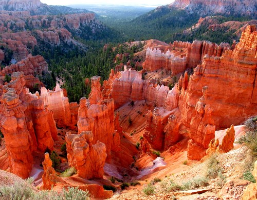
I find myself daydreaming almost constantly about different runs I would like to do, and I am almost always concocting plans to run epic trails and bag legendary summits. This is dangerous because it is so easy to lose focus of my research goals. I seem to find myself on Google Earth, Topo, and Summitpost more and more trying to find or formulate the holy grail of trail runs. It is almost an addiction (OK it is an addiction) of trying to build the perfect run, combining amazing scenery, technical trails, and major summits. Some of the areas I have been looking at are Bryce Canyon in Utah and Delano Peak in the Tushar Range. Another drawback to this daydreaming is the reality that time and funds make it impossible to even attempt more than one or two of these runs a year. I will definitely still give it a red hot go though!


The Hoodoos of Bryce Canyon are beckoning me to come and run in their shadows!


The 12,000' + Delano Peak in the Tushar range is high on my priority list for trails and peaks to run!

This week was a good one for music because I was able to discover multiple songs that I really like. I have been in a bit of a dry spell as far as finding music that I really love and keep listening to over and over again. The first song I found this past week was a Cover of Platinum Blonde's 80's song "Not in Love". The cover was by the Toronto based thrasher duo "Crystal Castles" and features the vocals of Robert Smith of The Cure. I really like how the song easily resonates out of the 80's yet has carried the sound into the now. Smith's vocals compliment the electronic music beautifully and this song played over and over in my head on my Saturday long run and I enjoyed every minute of it as I ran through streams, jumped puddles, slid on ice, and cranked out a great run. Great song and Cover. Enjoy!


Friday, December 3, 2010

Running out of land!

Yesterday's run was a bit different; I decided to run along the coast instead of my usual trails that are always draped over mountainous terrain. It was a nice change of scenery and coasts offer unique challenges of their own. For example, the rocky shorelines get hammered by wave action leaving them quite fractured, weathered and slick, many have large breaks and gullies you have to jump and climb over (you can get a small sense from the video I am posting, but the quality doesn't really do it justice). There is also something really awesome about running the strand line separating land and sea, as the waves are crashing and the wind is blowing off the water, it is almost therapeutic after a challenging week full of stress.

I chose a spit of land projecting into the Strait of Georgia as my goal for this run, and decided to run until I was completely out of land. It was actually really awesome and I am really enjoying what I am doing with my running; by shaking things up and running to many different locations it is keeping things fun, new, and exciting. I went out armed with my bulky camera (since it was another clear day free of precip.) and snapped some shots along the way including some funny self timer ones. Mixing photography and running is also making each run more exciting, and I really enjoy it. I would love to take my big DSLR with me but it is too bulky (but the quality is unmatched). My current camera I am running with is no pocket camera, unfortunately the photo quality is out of date and isn't proportionate to the bulk of the camera.

This run like previous runs was not that great, but it was fun, so I really can't complain. As soon as I can get consistent I will start seeing the results I am after.


Self-timer shot on the rocky point after running to the lands end.


This photo shows what coastal running near Victoria, BC is like. Lots of slippery rocks!


A shot of the skyline just as I left the trails and started on the roads back for home.


In honor of Christmas I decided a photo I took of this Holly as I ran by was appropriate.


This is a short video showing me run to the end of the point. Not the best quality but I wanted to film it. I have to admit I ran it quite gingerly because of the jagged rocks, I was concerned if I ate it that me or the camera could get chewed up so I took it easy and you can also tell I was pretty knackered by this point of the run. I hope it gives a small glimpse of what it is like running the coast of V.I. (It is best viewed with the sound turned off because of the wind and the Cure video playing with the sound on. I know I could have just added a soundtrack in moviemaker but I would have had to convert the video format so this was good enough.)


I decided to post some acoustic Cure today. A Cure song has been long overdue on my blog and "Close to Me" has been one of my favorite songs since I was just a kid. I remember being about 10 years old and falling in love with the upbeat melody. One day after Halloween I had to stay home from school because I ate too much candy the night before and made myself sick. I can recall laying in bed with my recorder trying to play this song. I never could figure out how to get the notes right but it is nice to know the 10 year old version of myself had pretty good taste in music even back then. Enjoy!

Sunday, November 28, 2010

Winter trail photos


Yesterday was my long run and I headed out to my usual training grounds to get some hill and distance training in. I took along my bulky camera and snapped some shots of the trail, since winter afternoons always seem to have such awesome lighting. I ran a little early before the best lighting right at sunset but still thought it was a great time to run. The run itself was terrible, I just couldn't keep my breath and my shoes are way past due for a replacement. My shins really took a pounding on the downhills. I have had inklings towards trying the La Sportiva Crosslite's instead of my Cascadia's I have been using for the last two years. I will have to try them on and see how I like them. My only concern is they really can't handle the roads like the Cascadia's based on reviews.

I really miss my really long gnarly trail runs and am anxious to start incorporating them back into my weekly routine again. I can tell that many of my trail stabilizer muscles have weakened a bit so I have some work to do. My hills are really poor so I can't wait to start pushing more elevation. It wasn't the best week for consistency or quality of runs but I am just working on my base and hopefully as my distances increase my weight will decrease and I can get back into that fit zone.