My best friend Tim and I will start to officially train for the 2013 season beginning on Monday. He lives in Utah about 900 miles to the southeast of my current home of Victoria, BC. So to train together we have to rely heavily on the miracle of technology i.e. social networking, YouTube (highdef video conversations), and e-mail. These modern conveniences let us stay connected as we train together and follow each other's progress while also carrying on long distance conversations about this beautiful art we call running. We will also be doing the same training program; one Tim has designed. This program is tailored to help us get back into the groove of running consistently between now and April (get the cobwebs out after the holidays) and then really hone our speed and endurance come the summer so that we will be able to handle whatever running adventure we can get ourselves into. Besides Tim's marathons and RAGNAR races he has planned, we are also looking at our yearly epic trail run to be a beast and I will blog about that in the future!
This past week I have tried to run some slow distance just to wake up my circulatory and respiratory systems while also conjuring up some muscle memory in my legs. I dropped off my Christmas tree at the University Track and donated to the track team to help support track and field athletics (the track team recycles trees to raise money). I then started my run at Mt. Douglas my usual training ground. The weather was perfect 9 degrees Celsius or 48 Fahrenheit; overcast with a bit of sun peaking through now and again. It felt like running in April in Utah but these conditions are quite common this time of year here on the island. I took my time and worked my way up the side of the mountain focusing on taking small steps at a faster cadence and also staying relaxed. The majority of the trails I run on are devoid of my fellow bipedal com padres since the trails I run require you to get muddy and are somewhat technical. I summited the big mountain and snapped a few shots but it was so crowded with others in the observation nest that I quickly dove off the gnarly steep side of Doug in full retreat. after picking my way down the exposed slippery rocks I ran the Km of slight uphill trail towards Little Mt. Doug; stepping in small spaces between roots and rocks. Little Doug is a small blister on the west apron of it's bigger brother. I really like Lil Doug, though much smaller, it also has a lot of personality (the trails do anyways). I chilled on the summit for a few minutes and reveled in the feeling of running free and the nice relatively warm weather. I bounced down the steep rocky face and finished my run on a trail that hugs the base of Big Doug and takes me back to the trail head. I saw that some of the underbrush was starting to already bud. How I love spring on the island! In Utah winter often gives way to summer with an extremely abbreviated spring (often only a week or so) but on the island spring dominates both winter and summer and often seems to make up half the year. I took little easy strides and focused on my form and got excited for this years training with Tim, and I tried to let that small burst of adrenaline at the thought of training with him carry me all the way to the finish extremely quickly. It was another great run and 2013 is turning out to be a great one. I gave this run 7 out of 10 bean burritos (with Serrano peppers, my after run snack).
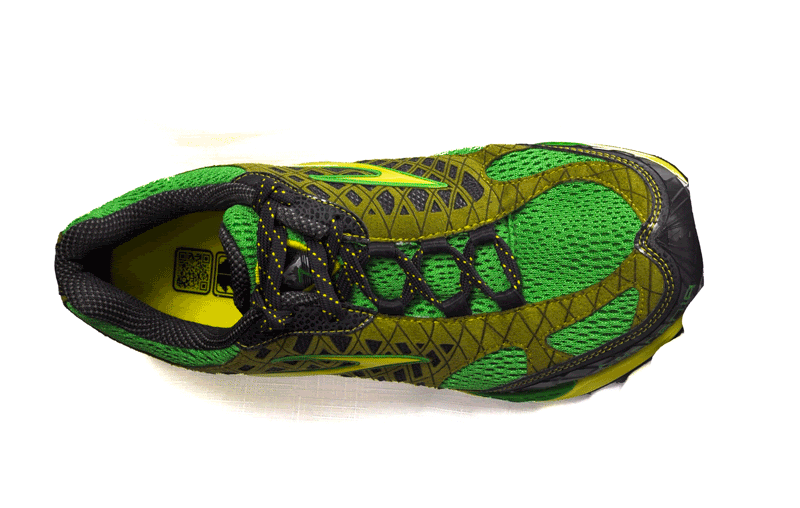
Heel-Toe Drop: 10.0 mm (improved from Cascadia 6’s 11.3mm drop)
Heel Height: 28.0 mm
Forefoot Height: 18.0 mm
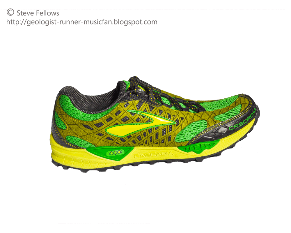
Before reviewing the Cascadia 7 I need to mention that I gave the Cascadia 6 a score of 21/25 in my previous review, and even though I reviewed the 6's after running 90 miles, it may have been premature considering several issues popped up later in the life of the shoe. More realistically the Cascadia 6 score was an 18/25. That said, my Cascadia 6’s ended up lasting for 1,600 miles before I had to retire them, and that includes over 600 of those miles on roads. The good news is that the Cascadia 7 addressed these issues that cropped up later with the 6’s and I am extremely excited about the updated 7. I will address these issues with the 6 and how the 7 has addressed the issues in this review.
OutSole
The Cascadia 7’s outsole lug design has been redesigned from the 6. The biggest change was the elimination of the round lugs in the core of the outsole of the 6 and returning back to a more triangular lug design in the core of the 7. This change was important because the round lugs in the 6 were not angular enough to grip crevices in rocks and seemed unable to cut through deep mud due to their large surface area. The round lugs also wore quicker and as they wore the traction decreased significantly.
Here is how this new outsole performed on the trails and roads and improved the shoe from the Cascadia 6.
Roads - The lugs handle the roads reasonably well for a trail shoe that is primarily designed for gripping rocks and mud. The lack of surface area in contact with the road on a luggy trail shoe does cause some slippage particularly on wet asphalt. The amazing thing about the Cascadia 7 is that the tread design is smooth enough on the road that you can actually run many miles on the road and have no problems. This shoe is no replacement for a nice road runner but it is as close as it gets. For a runner who has to navigate roads to get to the trails or run trails that have sections of road, this is definitely the shoe for you. I rated the outsole 3/5 for performance on the road
Trails - This is where the outsole and lug design of this shoe excels. The amazing thing about the Cascadia 7 is the fact that this outsole can handle muddy, rocky and root strewn trails nearly as well as specialist trail shoes designed primarily for nasty trails, and yet the Cascadia 7 can run roads making them a more diverse shoe without losing much performance compared to a specialty shoe. They grip mud extremely well. In the Pacific Northwest where I train, muddy trails are a constant, so it is key that the shoe doesn’t slip and the mud doesn’t stick to the sole. The Cascadia 7 nails this combination and can handle the soup and then releases the mud between strides. As for wet rocks they did as good a job as you can expect any versatile shoe. There always seems to be some slipping on wet rocks but the more triangular lug on the 7 seems to find better purchase in small imperfections in the rocks better than the Cascadia 6 so there is improvement there, but there is still slipping on wet slimy rocks. They handle dry rocks extremely well and the ballistic rock shield eliminates the shock from sharp roots and rocks and can handle long distances on rocky trails. Total score for outsole on the trails is 4.5/5.
Cushioning/pivot points/caterpillar crash pad
The Brooks Cascadia 7 incorporates the Brooks DNA cushioning system into the mid sole. This non-newtonian substance is supposed to give each runner a new tailored ride. They have kept the pivot points which are meant to prevent an ankle roll when stepping onto the side of your foot on a rock or root. There was little change in the cushioning from the 6 to the 7 because they really have the cushioning figured out.
Roads – Once again Brooks has found a way to cushion their shoe in a way that is virtually invisible. The shock of the road is adsorbed particularly for heel strikers due to the roll of the shoe and also from the collapse of the caterpillar crash pad in the heel area. Mid to forefoot strikers will find the shoe extremely comfortable on the roads even for long distances. As far as trail shoes are concerned this is the Cadillac of trail shoes on the road. I give the cushioning a 5/5on the roads.
Trails - Everything said previously about the cushioning on the roads applies to the trails but even improves more since the added softness from the trails makes the impact even less noticeable whether you are midfoot striking or heel striking from packed dirt to rocks and mud. The Cascadia 7 deforms around obstacles due in part to its pivot posts. The shoe definitely gets the full 5/5 for cushioning because of the pivots, the DNA, and Caterpillar Crash Pad that all work together to give you a custom, stable, and a shock free ride.
Upper
The upper has changed once again. The previous Cascadia 6 had an adjustable piece in the eye row, which I found to relieve pain in the bridge of the foot during toe-off, but over time I felt the elasticity allowed my foot to slide forward on steep downhill trails and my foot would begin to slide into the toe box. I was quite happy to see this feature go even though in my previous review I praised the elastic eye row as a smart innovation. To address this issue brooks has offset the entire lacing system to lock down the foot and take pressure off the bridge of the foot.
Roads/Trails - The new adjustments have definitely changed how the shoe fits. At first I thought the size 10 felt too wide, but as I worked on the laces it locked down across the bridge and finally tightened up in the toe box and seemed to feel closer to the previous size 10’s fit. The offset laces work really well and not only lock down the shoe in the arch area but release the pressure points across the bridge of the foot, improving the shoe from previous lace designs. The shoe goes from completely water logged from stepping in a stream or puddle to damp in about 20 steps so the shoe really expels water once it gets in there and even seems to draw water out of the wet sock and move it to the outside of the shoe. This is key for any long runs that have high probability for getting your feet wet. I had issues with the Cascadia 6 laces staying tied and thought the floating eye row may have allowed the laces to loosen up over time. The Cascadia 7’s seem to stay tied better than the 6’s but I feel there is still some room for improvement in the lace so that it doesn’t come untied or loose. The shoes upper receives a 4.5/5.
Overall I gave this shoe a total 22/25 scoring higher than my previous Cascadia 6 review and if you consider I feel the Cascadia 6 was actually lower, you can say the Cascadia 7 is clearly a major improvement. Most of this improvement comes from the lug design and the offset lace design. Once again I would recommend this shoe for a versatile runner who encounters the full spectrum of running surfaces from trail to track in any given day. There is still some wiggle room for improvement but Brooks has really developed a great shoe that any runner can take and excel in whether training or racing. This shoe is the Swiss army knife of trail shoes!
Here is a video of a run on Mount Work in Victoria, BC wearing the second pair of Cascadia 7's I have owned!
This semester was definitely an endurance event. Everyday felt like I was just trying to run to the next tree, or next stone, just like the late miles of a gnarly distance run. Instead of running to objects along the trail I was trying to just finish the next paper, the next assignment, or make it to the next meeting with my adviser. I was extremely relieved when it was all said and done and I could enjoy some down time with my family. I was also stoked to hit the trails again. So on Boxing Day I went out for a slow two hour run. I ran beach, I ran roads, I ran creeks, and I ran forest. It felt amazing! It was nice to actually be working towards my fitness and running goals again instead of buried in the books. The run was slow and painful but the light drizzle and beautiful Vancouver Island winter day recharged the batteries and I felt whole again.
Below are three shots from the run that represent the amazing variability and beauty I get to emerge myself in every time I run out the door.
Douglas Creek
Mt. Doug single track!
Arbutus Cove Beach
I haven't included much music in my posts of late so I am going to include a song that helped me through another brutal semester. This is a great song by Seven Mary Three an amazing and underrated band. They formed in 1993 in Virginia as teenagers but really broke out in 1995 with a hugely popular debut album "American Standard" and are a quintessential American band; two guitars, bass, and drums.
This song "Over Your Shoulder" comes from their 3rd and likely least popular album "Orange Ave." released in 1998. The band was having issues during it's recording, which affected its final sound, but it did have a nice song or two and this is one of them. The reason this song helped me this semester is that as I was pulling my first or even second all-nighter in a row, and I felt like just laying in bed and not ever moving again, I would throw on this song and soon I would rally as I realized that I just needed to hunker down and before I knew it the assignment or deadline would be "over my shoulder", and ultimately the semester was quickly behind me. It goes without saying that this song also applies to long distance running, we all come to those low spots in each run, each season, each year where the run or running isn't going exactly how you planned and everything seems to be going pear-shaped, but sooner or later it is over your shoulder. A nice song to pick you up when feeling overwhelmed. Enjoy!
This is a video I made at the end of summer of an 18 or 19 miler I ran at sunset. I like how you can see it getting later and later as the run progresses.
Few aspects of trail running are more appealing then swiftly ascending the slopes of a major peak. With each searing breath and lactic acid-laden step you propel yourself heavenward. Peaks represent a very real goal that can be met with awe-inspiring views and a lofty sense of accomplishment. Running trails that lack major prominence may not seem as worthy of a pursuit, but these trails should not be underestimated and can be just as challenging, beautiful, and worthy trails to seek out and run. Perhaps few trails exhibit a merit worthy of comparison with some of the western cordilleran mighty summits then the coastal trails of the Pacific Northwest.
The East Sooke Park Coastal trail is a true jewel tucked away along the southwest corner ofVancouver Island. Upon exiting your car the trail seems quite tame. A wide gravel path leads between evenly spaced trees in a large grassy meadow. The trail seems to be teaming with hikers and you instantly worry you are going to be crowded. The trail flows into a nice sandy beach and becomes the final destination for many of the people you see parked at the trailhead.The coastal trail then turns abruptly west along the shady southern coast. Giant western red cedars, Douglas firs, and arbutus cast their cool shadows over the rocky path. Ten minutes into the run you approach a petroglyphic panel of unknown age. It appears to be a depiction of a salmon or other sea critter. Once again you lose more weekend warriors on the trail, whose main goal was the panel.
After the petroglyphs the trail begins to become much more challenging. It begins to rise and fall over angular jagged rock formations with intermittent sections of yellow grass-strewn headlands. Running along one of the many headlands in the fresh ocean breeze is beyond words.On the horizon the jagged outline of the Olympics rises out of the azure waters of the Pacific Ocean. Foamy waves break on the rocky shore below as the gusty breeze blows the salty scent of the sea over the grassy headland. It feels like you are running through a painting as the fall of your feet brush a seascape across a remarkable canvas of stone and grass. Beechy head is perhaps the most prominent of all the view points along the trail and a concrete monolith marks the summit of the whaleback.
The real work of the trail starts after Beechy Head. Few hikers venture beyond this section of trail and it becomes more wild and secluded. The trail takes on a different persona; one of twisted rock and root with abrupt elevation changes. The next major point you run towards is cabin point. This is an old trapper-style cabin like the thousands that once dotted the BC coast during the early part of the last century. The cabin is available for use and is perched on a lonely wind-swept point.
After the cabin, the trail darts north into a large canyon and turns back on itself towards the south, skirting a large rocky hill. The remaining portion of trail continues to ascend and descend rocky coastal slopes. You catch glimpses of large cliffs and watch the full weight of each wave crash at the base, creating a very dramatic effect.
The trail then comes to a lovely little cove and beach, near the Pike Road access. Many people shuttle cars so that they can hike the trail once and then drive back to the original trailhead.Most hikers take 5-6 hours to do the full trail. As for me I had to turn around and retrace my steps all the way back. I didn’t have time to run the full length of the trail but came close. My family was waiting back at the beginning beach and I was hoping to make it back to them in three hours.
The EastSookePark coastal trail is a worthy and difficult trail. Every step must be adjusted for as each foot plant is on uneven rocky or rooty terrain. It becomes a struggle to climb and drop over each large headland only to have to repeat it over and over. Soon the quads ache and the calves beg for a stretch of flat easy running so they can recover. The views almost can’t be beat.This trail is highly recommended but if you are planning on doing the full out and back it could easily take 5 hours so be prepared for a long day on strenuous terrain.
Week 3 was not as great as I had hoped. I am trying to get a scientific publication in the works which is a time consuming project. I also had family visit which cost me a day of running and school work. I compensated by doubling Wednesdays mileage but many of those miles were on a road which beats me up a little worse then on the trails. Over all I was happy with the 32 miles I achieved but it definitely could have been stronger.
This is a little late considering week three is a day from being over but here is my Vlog on training for an ultra for my second week (it is a little quiet in places and once again the sound is off in a few spots but that is what I have to work with as far as my camera mic goes and also my editing software).
I finally had a chance to gather up all my media and piece together my video from an attempt to run to the summit of Ben Lomond with my best friend Tim on July 2nd. You can read about the run and watch Tim's video here. My video isn't edited as well as I would have liked (issues with matching music and transitions etc) but I think it does a good job of showing what a great run it was even though we weren't quite able to summit!
During the end of June and the first week of July we traveled to Utah for a holiday. I had planned on running a couple of awesome runs with good friends. The extremely cold wet year eliminated the possibility of running the main route we had chosen so we had to get creative and find something new to run. To test how runnable the Northern Wasatch were and to see what options we had to replace our old run, I decided to take a test run up Bair Canyon which is the course for the Bairgutsman trail race, an 11-13 mile point to point trail race. I was running about 8 miles of the course and then running back so in total I was going to run 16 miles.
Starting at an elevation of 4800' the trail heads straight up Bair Canyon to the summit at 9,500' leaving the total elevation just shy of the 5,000' mark. I started the run at 5:30 a.m. hoping to beat the sun since I am use to running in the mild climate of the PNW. It was quite windy at the start but it was still fairly warm. I had some concerns about the high run-off that would make each of the four river crossings a bit dicey and I was also worried about the snow fields near the summit that were going to be treacherous to cross.
I started off at a nice clip and made it to the first river crossing very quickly. The river was high and frothy but it looked relatively safe. I jumped on in and felt the icy snow melt crash into my thighs. It ended up being quite simple to cross and I could tell I wouldn't have any issues crossing each of the subsequent crossings.
The trail had not seen many hikers past this first crossing this year and the trail began to be quite overgrown. Perhaps the most challenging aspect was the loads of stinging nettle that lined both sides of the trail due to the extremely wet conditions this year. I startled some campers who were sleeping on the side of the trail and weren't expecting to see anyone let alone at 6:00 a.m. I waved and crossed the river again and kept on cruising upwards.
I was also getting covered in hundreds of tiny silkworms that were dangling from the trees. Sometimes I would stop and pick hundreds of the little creatures off of me. Then I noticed a few other unwanted guests hitching a ride... Ticks! I picked several of those off my bare legs and then spent the remainder of the time in the trees and brush petrified of having to pick off ticks when I finished my run. I also began to notice cougar scat all over the trail and was a bit nervous, when a large sage grouse jumped out in front of me. Being already nervous of cougars this opportune explosion of feathers made me nearly have a heart attack. With a huge jolt of adrenaline I powered my way up through the remainder of the trees into the higher slopes of the range. The trail was extremely faint in places making it challenging to follow but my main concern was that on the return down I could easily get lost since the trail would be harder to see as I quickly bounded down the hill. There was also going to be a bunch of branches from mountain mahogany and scrub oak and nettle to sting and scratch my legs as I made my rapid and slightly out of control descent.
I reached snowline at about 7:00 am and found my first snow crossing to be treacherous as I had to slide down a nearly vertical 20' foot snow ledge on my backside. The next challenging snow field was a large side-sloped traverse that angled steeply into the canyon and would have been really bad to slip and slide down on. After crossing this side slope I realized all the switch backs were covered in snow and ice so I just cruised right up the ridge getting scratched and torn up along the full distance.
About two hours after starting out I made it to the summit ridge. The wind was really whipping up there. I decided to summit a small peak to the north of Francis Peak and have a sandwich. I took shelter from the wind behind a communication tower and had a great time on the summit. I changed my socks and started the descent. It went really quickly and running down the snow fields was a blast.
As I predicted the branches and nettle took their toll on my exposed skin and my legs were completely shredded and stung. It is all part of the journey. The descent went extremely quick and I got off the main trail during a slide-rock crossing but found it again and finished my descent with no major issues.
It was a great run and one I will always remember. I really love running in the clouds. Enjoy the footage I took of the run!
I went down to Utah at the end of June with the intention of running from Smith and Morehouse to Bald Mountain in the Uintas with my best friend Tim. The problem was that even though we waited to do the event until the first week of July, the weather had been so cold and wet this past spring that the Uinta Mountains were completely snowed over.
We had to think fast and come up with an alternate idea. I decided to take a test run to 9,500' in the Wasatch Mountains and see how the conditions were. I ran to Francis Peak and found that it was no problem if I stayed on south and west slopes of the range (more to come on that run). The north slopes were still quite snowy but it seemed reasonable that we could handle any run in the Northern Wasatch.
So while in North Ogden I stopped off at Tim's house and decided to talk to him about our options. We set our sites on 9,712' tall Ben Lomond. The idea was to hit the North Ogden Divide and run the south ridge all the way to the summit. Here is where we ran into our next problem. Tim called me that night and informed me that the North Ogden Divide was closed due to rock slides. We couldn't really get anywhere near the trail head. We devised a new plan to attack it via the east and north slopes of the North Fork Park (I knew that we would be dealing with some serious snow).
We met at about 5:30 am and drove to the trail head. The sun was already beating down on us as we started the run. We didn't quite know where the actual trail started and ran around the campgrounds a bit to find the actual trail near some corrals, which allowed us to stretch the legs and get the cobwebs out. I was still a bit fatigued from hammering a 13 mile 3,000' run just two days earlier and I could tell the elevation and heat would slow me down but in the end I could care less the mountain air was fresh and crisp, the sky a sapphire blue, and we were doing what I love most about running - propelling ourselves skyward!
The first few miles were beautiful and the trail was in great condition. We were able to quickly move up the mountain in good time. We purposely held back and took our time because we knew that the upper reaches of the mountain weren't going to be a picnic. After several miles of smooth sailing we began to ascend into ever higher trails and then ran into our first snow bank. The snow was soft and made a steep bevel that covered the trail. The edges of our shoes bit into the snow and we navigated the bank with little difficulty. The next bank was a bit longer and more solid than the previous one. Tim, being a road marathoner, was wearing his Mizuno Wave Runner's which have about 600 miles on them. We joked that he was doing an off-road event in racing slicks. This was Tim's first real trail running attempt and as we ran the snow I could see that his shoes were not going to handle too much snow but I thought "it is July, how much snow could there be up there?"
As we made continual progress up the slope we found the snow becoming more and more common. Finally it began to no longer be just a hindrance but a hazard as we side-sloped large ice fields with seemingly endless drop-offs. The once amazing and runnable trail was masked by large snow fields. We would continually lose the trail and have to find it after zig-zagging the snowy slopes. With all the challenges the snow were posing we began to work out a system where I would kick steps into the icy pitches and Tim would follow in my footsteps with his racing slicks. We found a smooth rhythm and began to make some good progress again. After several slow miles of kicking steps and finding the trail we reached a large gully that was choked with snow and ice. We could see that it lead toward the saddle that marked the beginning of the final approach to the summit. All we could see though was white. There was little hope of being able to ascend the last 600 feet without a better form of traction. With disappointment I told Tim that with a pair of Kahtoola Microspikes we would be able to launch ourselves right up the slopes.
We decided to run around a large hip that protruded from the slopes of Ben Lomond. As we rounded the corner we were met with the awe-inspiring 9,764' crags of Willard Peak. All I could to do was drool as I imagined myself standing on its summit in a perfect "snow free" world. Alas it was not to be. It would have been unwise to continue with racing-slicks and besides our unprotected eyes were now looking at the blinding light coming off the snow fields for an hour or two and snow blindness is something neither of us wanted. We decided to call off our summit bid and we anxiously looked back over the miles of mushy snow that stood between us and fast downhill running.
We picked our way back but continually were having issues following our footsteps back and after some confusion we realized there was a subsequent pair of insane runners like ourselves that had attempted the same run. We eventually ran into them as they descended as well having suffered our same fate of getting snowed out. We joked and shared running stories and enjoyed the unspoken bond that links all crazy runners. We all parted ways and began to pick up the pace as the snow thinned out more and more with each step.
Finally we reached the sloping trails leading back to the trail head. After several hours of slipping and sliding and kicking steps in the snow we were able to finally run! We pointed ourselves down hill and really turned up the heat! We floated down the gentle curves of the wooded apron that surrounds Ben Lomond. Leaping streams and flying across slopes covered in lush green grass and wildflowers, we finally felt more like runners and less like mountaineers.
The heat of the day and humidity rising from the dense vegetation gave one a sense of running in a sauna. Before we knew it we were down from the mountain and just meters from the trail head. Our water had run out just as we reached the car. We had given it our best shot and though we were unable to summit something told me as we stood side by side gazing at the blinding jewel that marked the summit we would be back. Tim may be able to run it quite soon but I live 900 miles to the northwest and will have to wait for another year. Perhaps next year I will be able to give it another go and we may even be able to nail Willard while we are at it.
Perhaps the highlight of the trip was running with Tim. Our running journey's have followed completely different paths. I have been running for almost 5 years now and have found myself drawn to the trails of British Columbian, where Tim has been running for only a year and a half and has spent most of his time on the roads training for half and full marathons. That being said two best friends of nearly 20 years who have polar opposite running styles and backgrounds were able to reconnect and share our first of many running experiences together and enjoy the camaraderie and joy that comes from running. Something tells me this is just the first page of a whole new chapter of our friendship.
Tim is currently spending the week with me on the island and we are already creating new and amazing running experiences here. I will blog about these amazing runs in the weeks to come.
Here is a video made by Tim of our amazing run. I have not been able to gather all my multimedia from the trip yet but will post it soon. I love the video Tim made and I feel it does a beautiful job of catching the amazing time we had during our first run together ever. Enjoy!
I went down to Utah at the end of June with the intention of running from Smith and Morehouse to Bald Mountain in the Uintas with my best friend Tim. The problem is that even though I was waiting to do the event until the first week of July, the weather had been so cold and wet this spring that the Uinta Mountains were completely snowed over.
We had to think fast and come up with an alternate idea. I decided to take a test run to 9,500' in the Wasatch Mountains and see how the conditions were. I ran to Francis Peak and found that it was no problem if I stayed on south and west slopes of the range. The north slopes were still quite snowy. I had a great run and will block about it later.
I awoke on Saturday mentally prepared to run my first mountainous marathon of the season.I decided that I would run the Mount Doug Marathon.It isn’t an official marathon or race and the only entrant was me, so I knew I had great odds of getting first place, I just had to finish.
My training plan only called for a 24 miler but I was inspired by my friend Tim who was 800 miles to the southeast running in his first official marathon the OgdenUtah marathon, one of Runners World’s top 10 road marathons. I wanted to support him in his first marathon and celebrate his accomplishment of training consistently through the heat and cold of Utah’s extreme weather. Being in Canada and far away like I am it just wasn’t possible to be there in person. I decided I would run a marathon of my own in his honor and somehow I would be there with him in spirit.
I ate some breakfast of two fried eggs and some toast and jam.I have not had to really focus on fueling or hydration during long runs yet so I used this as an opportunity to see how well I could do. I packed a variety of snacks such as salted potatoes, peanut butter and honey, banana, and chips. I also packed 32 ounces of electrolyte drink and brought a gallon of water to fill my 16 ounce handheld.
The course I created is 4 loops and each loop is 10.5 km long and includes 3 summits and about 1500 feet of elevation gain and loss for a total of 4 loops, 12 summits, and 6000 feet gained and lost. After each loop I would pass by my car and be able to refuel and fill up my bottles.
I arrived at the designated parking spot to a chilly 55 degree and overcast day.It would be perfect conditions and allow me to properly cool off. I grabbed my bottles and started out nice and easy.My plan was to do each loop in 1 hour and 15 minutes for a total of 5 hours for the marathon.
Loop one was actually a lot more difficult than I anticipated. I didn’t get a ton of training in over the last few weeks and have been quite stressed and it was reflected in my heavy-footed trot towards the first summit. My goal was to quickly power hike all the 12 uphill’s and bomb the downs to make up time.The first 3 hills were quite easy and felt like small blips in my path but I knew they would get harder as the day progressed. Loop one was quite easy and I had to force myself to drink just so I could stay on point with my hydration. I flew through the last mile of single track quite quickly and reached my car at 1:07. Too fast I thought but no bother.
At the car I grabbed some corn chips, and ate about one red potato worth of salted potatoes. They tasted good and I washed it down with about 4 ounces of electrolyte drink. I refilled my hand held and got out of my car in about 3 minutes.
Loop two was by far the strongest of the four.I hit my stride and ran the flats with ease. I floated over the trails with my feet barely making contact with the ground. I grinded up each of the hills and tried to engage the glutes to take some stress off the quads and calves. I felt great!I had to really pull back on the reins because my body wanted to run the loop in less than an hour but I knew the run wasn’t even half over. So I forced myself into a painfully slow trot.During the last mile I had to hit the bushes.One challenge that is unique to me from other runner’s is the fact that I don’t have a large intestine and my food has a very short residence time in my digestive track. Running seems to speed the process along and one hour after eating seemed to do the trick for needing to hit the bushes. I quickly took care of business and hurried back to my car. This time I took 1:10:00 on the loop.
I ate half my PB&H and also downed about 8 ounces of electrolyte drink. I ate more potatoes but decided to opt out of the corn chips which seemed to make a reappearance several times during the previous lap (not that I puked or anything but you could tell they were being burped up).I spent 3 minutes at the car again.
I have run many runs this year that covered the two loops for a total of a half marathon on MountDoug.This was the first time that I ever went beyond the 6 summits and 13 miles. So as I started loop three I was entering new hallowed ground. I love the feeling of pushing into territory that I have never done before.
Summit 7 quickly reminded me that I had just climbed and descended 3,000 feet over the last two hours and had 6 more to go. I began to slow a bit and my lactic acid threshold began to deteriorate. The long gentle uphill stretch between summits 7 and 8 proved difficult and I took a small walking break for about 1 minute. This really helped and I was able to finish summits 8 and 9 with some discomfort but nothing too bad. Once again I had to head to the bushes at the exact same point as the previous loop. I guess I know that on long runs I have about 1 hour between eating until I have to find a stump. Good thing I run trails and not roads!I reached my car at a much slower time of 1:15:00 for the loop and the slower up hills and extra walking breaks all took their toll and I got a much slower loop.
At the aid station I dumped debris from my shoes, ate the rest of my sandwich, my potatoes, and my banana.I drank the rest of my electrolyte drink and took a deep breath. I had 10.5 km to go and 1500 feet of vert still to go and I was feeling it.
Summit 10 was brutal.My legs felt like jelly and there just wasn’t any strength left in them to draw from. The descent began to show me weaknesses in my downhill conditioning and for the first time this year I felt my quads begin to really get chewed up on the descent. The long slow grind up to summit 11 was absolutely brutal.I began to think about my friend Tim and wondered how his race went. I kept on trying to draw some strength from him and think about how he was covering the same distance at a much quicker rate in much higher temps. Somehow I knew he had run well and this seemed to give me some extra motivation. Yet I still had to walk most of this shallow stretch.My legs were just knackered!The last 5 miles were brutal and the last two summits were quite taxing. After the 12th summit I just had one long stretch of down hill to go. This is where the problem lied.Six-thousand feet of descent had taken its toll on my quads and they felt like they had gone through a meat grinder. I couldn’t believe how sore they were on the final descent. Suddenly my knees began to hurt and I realized my fatigued quads were not supporting my knees any longer and they were starting to track poorly and get inflamed. Rather than risk further injury I slowed down to a crawl and just coasted the last couple of miles. It wasn’t the strong finish I had in mind but I finished a really hilly and technical marathon at 5 hours 1 minute and 30 seconds. I would have loved to get a sub-5 but that was all I could do without getting injured.
What a great marathon!I can’t wait to improve and continue to work on my distances. I only lost 6 ounces during the run which was a testament to my attention to detail with my fueling and hydration. I only got sick once at the final summit and only for a few minutes. Overall I was quite happy with my first 5 hour run of the season.
Today’s song comes from the land of my roots Sweden and is from a Swedish duo called Familjen. The song is called “Det snurrar i min skalle”.I love the song though it is in Swedish.I also thought it fitting since the footage of the video comes from a Swedish faith healing evangelist from the 60’s, and since it was supposed to be the end of the world during my marathon I thought some sweet footage of this evangelist put to this awesome song was a nice fit.Enjoy!
I awoke this morning and loaded my running pack with 2.5 liters of water, my camera, and a peanut butter and honey (PB&H) sandwich. It was going to be my first 4 hour run I have done for many months. Since I am running strong and consistent, I felt I was ready to start doing what I love most- long runs with loads of relief.
I picked the Gowland Tod Range to run for several reasons. First it starts at about sea level and climbs as high as about 1350 feet at Jocelyn Hill and then dives down again and back up to 1000 feet at Holmes Peak after which you turn around and climb them both again in reverse. In total it has some good elevation and relief. The second reason I love this route is the views are breath taking. The entire trail parallels the Finlayson Arm of the Saanich Inlet and you can see the ocean, surrounding mountains, and forest. I believe every trail runner should have an opportunity to run this course at least once in there lives.
The weather was superb without a cloud in the sky and temps were hovering around 60. After arriving at the trail head I started my run and within about 10 minutes found myself cranking up the first hill, which climbs unrelentingly for several miles. The trail is rocky and winds it's way from near the ocean south towards Squally Reach. My legs were a bit tired from this week's runs but once I started motoring up the trail I began to relax and find my pace. Though not the fastest pace, it was maintainable and comfortable, and I knew it would last for 4 hours so I stuck with it.
Squally Reach in the Gowland Tod Range. Floating over the grassy hummocks!
I arrived at the squally reach lookout and drank in the most amazing view. I could see the ocean and Salt Spring Island, even Mt. Baker was dimly visible looming over the eastern skyline. I ran across the grassy hummocks and could swear I was floating.
After playful running on the reach I began to turn my attention to summiting Jocelyn. Jocelyn is a large grass covered blister rising nearly 1400 feet above the ocean. The trail from Squally Reach to Jocelyn undulates and ascends and descends over uneven terrain. Though most of it hovers around the same elevation there is plenty of ups and downs to keep you earning your forward progress. You feel you are nearly to the summit but then the trail turns north and you almost back track a Km before curving around to the south again. After turning to the south you begin to overlook the ocean once again and the views are breathtaking.
Approaching Jocelyn Peak with the Saanich Inlet behind me.
Leaving the Summit of Jocelyn.
The summit was a perfect place to stretch out on a rock and enjoy my PB&H. The sun cut through my sweaty shirt, warming my body all the way through. I closed my eyes and just let my mind wander. My thoughts turned to my summer plans and I decided that I really want to hike Lone Peak with my wife. Lone Peak is an 11,000 + footer rising directly over the Salt Lake valley with nearly 6,200 feet of prominence, it is not for the average weekend warrior.
When we were first married we would hike almost year round often in remote and unknown places. I recall many long drives in my jeep as we listened to music and discussed everything from our favorite movies to our future plans. These trips made our relationship grow so much stronger and created a depth that wouldn't have existed without these precious adventures. Now after the children have arrived I realize that I really miss hiking with my wife and I decided I will take advantage of having family around this Summer to watch our kids while we go and have another adventure. I hope Vye will be game. I snap out of my daydream and decide I better get busy and continue on to Holmes Peak.
Holmes Peak is the small blister (barely visible) in the foreground on the ridge with the taller hill behind it being Mount Finlayson.
The trail to Holmes Peak is very straight forward but I still veered off the main ridge and descended about 500 feet to a main road and realized I just tacked on about 3 extra miles and 500 extra feet of elevation up and down. I don't care, there is no need to stick to a plan I am just running where ever I feel like it. I regain the ridge and decide rather than turn around I will continue on to Holmes Peak.
Trail towards Holmes Peak.
Trail to Holmes over some rusty (gossanous) soil.
I reach the small peak and push quickly to the top. I then decided to finish my sandwich and get heading back. The sun is much warmer now as the day has progressed but I don't mind, I missed the warmth during the sun's 6 month hiatus from the Island. I worked my way back towards the arbutus tree-strewn ridge that hooks back up with Jocelyn. I am now feeling the distance and time on my feet. My legs are toast as I continue to climb.
I forgot the feeling that comes after several hours of hard trail running. The legs ache and elevation is not won so readily. I persevere through and begin to push a bit just for fun. I summit Jocelyn again and take one last look at the view.
The undulating terrain between Jocelyn and Squally really takes it out of me. I begin to have to power hike a few of the steeper hills and I can tell my body is burned out. After a long struggle I reach the Squally and only need to run down hill from that point. The quads feel like they have just gone through a meat grinder but I like it in a way only a distance trail runner could understand. I can feel that I really pushed myself and that I was operating near my maximum for the day. I know that I put everything I had to give into the run and I know that I am back to running 4 hours again. Everything is right in the world, I got the treasure that comes after you have done everything you can. My hydration and fuel were on point and I never felt thirsty or hungry. It was a great day! As I drive home I analyze my run and feel satisfied with it. I can't wait to try it again!
The video below is of the same trail but I made it a different day. Enjoy!
Today's song comes from Finland by a small duo named "Villa Nah". They are a synth duo with many great songs. Today's song is called "Emerald Hills" and though it really wasn't in my head during the run it kind of summed up my run today as I was climbing an emerald hill. I like the song and think that it fits perfect for spring trail running on Vancouver Island.
Week two of my training for the Smith and Morehouse to Bald Mountain went well. I started the week with hill repeats on Mount Doug. I absolutely love hill repeats, and I believe that hill repeats on steep terrain propel my fitness forward quicker than any other form of training (with the exception of long runs). After a brutal long run last week I took Sunday to rest and then hammered the hills hard on Monday. On Tuesday I had my best run in perhaps 6 months (probably a combination of the previous long run and the hills) and I actually had my first runner's high in some time despite the down pour. I ended up having some pain with my biceps femoris ligament in my right leg pit. Two days of rest and I was good to go.
Saturday's long run was amazing, it was one of those runs where you can feel your body making the change towards being more efficient and fit. I decided to crank out a full Mount Doug Gutbuster (2009 course) along with my distance from my house and back. Distance-wise it is about a half marathon, but what was so exciting is how much longer I could run (40 minutes longer) than last week's long run. Not only that, but I ran considerably stronger this week. I was able to keep drawing from strength and reserves that last week just weren't there. I must admit that I have upped my calorie intake each day this week up to nearly 2200 from last weeks 1600 and that has made a major difference. The Gutbuster was challenging in that Vic has been pounded by rain this week with almost 4 days without a break. The trail conditions were terrible as far as speed goes but they were fun and muddy. Half the trails were running streams, draining all the rain from the wooded water-logged slopes of Mount Doug. The flats were riddled with standing water in many locations, and every trail was muddy except those composed of solid bedrock. Speaking of bedrock, the north descent down the "bedrock buster" was absolutely treacherous. They were the most dangerous conditions I have ever experienced on the Mountain. The cold north-slope spends the majority of each winter day in shadow and as a result the entire route was laced in a solid glaze of black ice from the draining mountain. Every step was a roll of the dice as to whether you would still be standing or not. I did quite well up until the bottom quarter where I finally reached a point where the icy-rock, my speed, and gravity made the perfect storm and I went down hard. I bounced pretty good off my left butt cheek and caught myself with my left arm nearly busting my wrist and hand. I slid about 15 feet until I caught. I quickly picked myself up, did a quick triage (quickly realizing all was well) and then carried on. I sometimes forget that one wrong step could spell disaster and cost me a season of training and running or worse. Next time the bedrock buster is icy I will choose an alternate route down the mountain so I don't bust something and cause problems. Below is a picture of the upper reaches of the bedrock buster in Summer without the ice.
"Bedrock buster" in Summer. Picture it covered in a layer of black ice and then run down it (treacherous)!
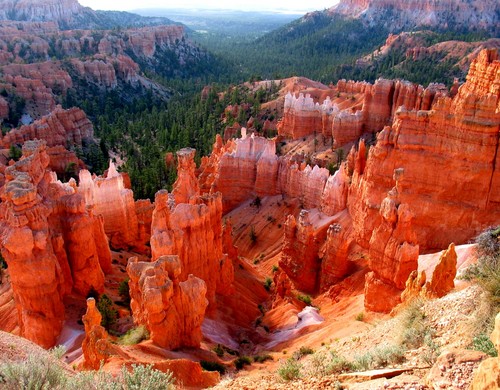
I find myself daydreaming almost constantly about different runs I would like to do, and I am almost always concocting plans to run epic trails and bag legendary summits. This is dangerous because it is so easy to lose focus of my research goals. I seem to find myself on Google Earth, Topo, and Summitpost more and more trying to find or formulate the holy grail of trail runs. It is almost an addiction (OK it is an addiction) of trying to build the perfect run, combining amazing scenery, technical trails, and major summits. Some of the areas I have been looking at are Bryce Canyon in Utah and Delano Peak in the Tushar Range. Another drawback to this daydreaming is the reality that time and funds make it impossible to even attempt more than one or two of these runs a year. I will definitely still give it a red hot go though!
The Hoodoos of Bryce Canyon are beckoning me to come and run in their shadows!
The 12,000' + Delano Peak in the Tushar range is high on my priority list for trails and peaks to run!
This week was a good one for music because I was able to discover multiple songs that I really like. I have been in a bit of a dry spell as far as finding music that I really love and keep listening to over and over again. The first song I found this past week was a Cover of Platinum Blonde's 80's song "Not in Love". The cover was by the Toronto based thrasher duo "Crystal Castles" and features the vocals of Robert Smith of The Cure. I really like how the song easily resonates out of the 80's yet has carried the sound into the now. Smith's vocals compliment the electronic music beautifully and this song played over and over in my head on my Saturday long run and I enjoyed every minute of it as I ran through streams, jumped puddles, slid on ice, and cranked out a great run. Great song and Cover. Enjoy!
Winter relaxed it's frosty grip today and teased the island with a slight glimpse into the impending spring. The weather was brilliant and temps were in the 50's the sun was blazing and if I didn't know it was January I would swear that it was some time in March or April. Hundreds of bikers and jogger's (fair weather wimps) were out in droves. I seized the opportunity to try a new trail out that I have been wanting to run for some time. This is a trail that begins near McKenzie Bight on the Saanich Peninsula and quickly climbs into the Gowland Tod Range that make up the eastern shore of the Finlayson Arm. I discovered this area last Summer with Vye and the kids and knew it would be perfect to run because of the challenging terrain and steep single track trails stretching along the hilltops and overlooking the inlet. It is surprising that I had not ran it yet up to this point. I finally decided to try it today. I chose a destination that would make about a 15 km out and back and would summit a high point know as Jocelyn Peak.
I started out flying down a steep ravine on a wide but muddy trail that hit the ocean at the Bight, I crossed a bridge and quickly climbed up a series of steep stairs, rocks and single track. The trail really didn't level out for almost 35 minutes of running and I found myself pushing with everything I had to run and power hike my way from sea level to over 1450 feet with cumulative elevation near 2000 feet. The trail was well drained and rocky and so mud was not an issue. It was surprisingly lonely on the trail. Once I made the ridge of the Timberman Trail it was smooth sailing to the last climb up Jocelyn peak. I had only passed one small trio hiking back to the Bight along this entire stretch. I felt so secluded I even purposely made noise to ward off any bears that might be out and about. Perhaps it was the jitters that come with running by yourself in the bush with nothing but the clothes on your back and your runners. I am always a little more cautious about animals in the early spring and thought any bear would love the warm weather as much as I was so I wasn't taking chances. The overlook above the Finlayson arm at both Jocelyn Peak and several other lookouts along the way were breathtaking. I wish I had a light camera to run with because today was unreal as far as crisp air and vivid colors are concerned. Once I summited I took 10-15 minutes and enjoyed the seclusion and view.
I don't know when I became such a hermit. Anyone who knew me in my late teens and early twenties knows I was anything but an introvert, but in the last 5 years I find I tend to prefer solitary and almost lonely circumstances to social environments, I don't even necessarily prefer to have company while running. I even feel a bit awkward like I don't quite fit in, in any situation that involves more than two people. My passions and intensity in which I pursue them tends to be way out there and that may be why I often find myself alone. I have often thought that perhaps as you make your way further along the educational progression line you begin to find it harder to make the same meaningful connections that were so easy earlier on in life. Perhaps it is just me, and my ideas on education have little to do with it. I know my dad was quite solitary keeping to himself and I often found him lying in the dark listening to music or in his chair reading, and he always hiked by himself. I guess the apple doesn't fall far from the tree. Perhaps because I have his genes and observed him when younger, his introverted behavior has taken root in myself. This may be why I find endurance trail running so appealing. It gives me an opportunity to be alone with my often fragmented thoughts and to focus and clarify them while having meaningful and even epic experiences in amazing places. I enjoy the sound of my feet on earth and rock and I have done some of my best research and writing while flying over miles of trails on Vancouver island. All of the extra oxygen associated with respiration and release of various chemicals in the body may help to nurture the thought process as well. Just some thoughts about my case of "Hermititis" I had while on the lonely trails today.
One thing I didn't plan on is dehydration. I quickly became parched in the drier and warmer weather than I was used to. After I had been running for over an hour my thirst level went through the roof. I could tell that I had lost some electrolytes as I began to have some small aches and pains that I usually link with dehydration. The entire run back to the car I was really wishing I had carried 32 ounces of water. The return run was all down hill and so it went fast enough that I ended up being fine, but if I was hydrated and had some fuel I would have ran much quicker on the way back. I will keep this in mind for my future runs in the park.
It was a delightful run and I will definitely incorporate this new trail into my training regime. This type of trail and terrain is perfect for improving my endurance and building my legs and lungs for the future endurance goals I have. This trail is also part of an unofficial race know as the Full Monte and "Half Monte" (50Km and 25 Km respectively). I think I will give one of them a try this year.
Below is a video I made of the same run but a little after I wrote this article enjoy!


